

Places with a View
| A - E | F - L | M - R | S - Z |
Bass Point
Located at the southern tip of the Lizard Peninsula, in the civil parish of Landewednack. The headland was a communications centre during the Victorian era, with the Lloyds Signal Station, opened in 1872 for shore to ship communications, and Marconi's experiments with wireless at the Lizard Wireless Station.
Bedruthan Steps
A beauty spot on the north coast north of Newquay overlooked by The Coastal Footpath. Its precipitous cliffs and spectacular rock formations above the sandy beach are covered with nesting sea birds and carpeted in summer with wild flowers. Local pub is The Inn at Bedruthan.
Black Head
A headland at the western end of St. Austell Bay. It is owned by the National Trust. It is the site of an Iron Age promontory fort. A memorial stone for the Cornish writer A. L. Rowse is situated on Black Head. In retirement he lived in the nearby hamlet of Trenarren.
Bodmin Moor
Desolate granite moorland overlooked by summits of Brown Willy (1377 feet), Cornwall's highest point, and Roughtor. Abundance of Neolithic and Bronze Age remains. In the centre of the moor is Jamaica Inn and, to the south, Dozmary Pool of Arthurian legend. Siblyback Lake is near the southern edge of the moor, and Colliford Reservoir in in the centre. There are also many mines and quarries on or close to the moor. Most of the tors offer amazing views.
Brown Willy
Highest point in Cornwall at 1377 feet. Situated in the centre of Bodmin Moor to the north of the A30 road, it dominates the moorland scene. There are hut circles and tumuli on the slopes about its long-ridged peak. Source of the River Fowey is on its eastern slopes.
Cambeak Point
Just south of Crackington Haven.
Cape Cornwall
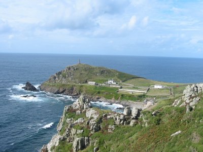
Situated in the far west of Cornwall, on The Penwith Peninsula four miles north of Land's End and Sennen Cove, the spectacular hump-backed Cape Cornwall, with its chimney stack, is the only cape where two oceans meet in England. It rears 229 feet out of the sea to a summit which offers a 270 degree view over the Western Approaches well worth the steep climb. Off shore lie the Brisons, an underwater reef that has caused many a shipwreck. Excellent stop for those waling The Coastal Footpath. Rare plants and birds give the area an extra special appeal today.
Caradon Hill
Located on the south-eastern corner of Bodmin Moor and reaches a height of 1213 feet above sea level. The television mast rising above the summit of this ancient hill can be seen for many miles around. Copper was discovered here in 1837, and signalled the beginning of the mining boom which changed the character of the eastern moor, and gave birth to many local villages such as Pensilva, Crows Nest, Darite, St. Cleer, Tremar and Upton Cross.
Carn Brea
The 812 foot summit of Carn Brea has an extensive viewpoint with dramatic views over Camborne and Redruth towards the north and south coasts, and it is visible itself from most of West Cornwall. Carn Brea Castle Restaurant on summit.
Chapel Point
Between Portmellon and Gorran Haven on The Roseland Peninsula. Marks the western edge of St, Austell Bay. The three houses on the point were designed and built by the architect John Campbell during the late 1930's.
Clodgy Point
Just West of St. Ives and right on the Coastal Footpath.
Compass Point
On the coast at Bude, it has an octagonal lookout tower, known locally as the Pepperpot.
Cribba Head
On the south coast of The Penwith Peninsula, just south of Penberth.
Cudden Point
Between Penzance and Porthleven on The Lizard Peninsula. Close to Prussia Cove with views to St. Michael's Mount.
Dennis Head
On the southern side of The Helford Estuary.
Dodman Point
The highest headland on the South Cornish coast. Located three miles south of Mevagissey on The Roseland Peninsula. Iron Age earthworks and medieval field systems of Dodman Fort on the headland between Gorran Haven and Portholland. The large granite cross was erected in 1896 as a navigational aid for seafarers.
Dizzard Point
Two miles north of Crackington Haven.
Doyden Point
Located at the mouth of Port Quin's inlet, is a fine feature of North Cornwall's dramatic coastline.
Dr Syntax's Head
The westernmost promontory at Land's End.
East Pentire Headland
A historic clifftop site situated on the southern edge of Newquay between the famous surfing beaches of Fistral and Crantock. The site has evidence of human activity dating back over 8000 years and contains a number of archaeological remains, including Bronze Age barrows. Managed by Cornwall Heritage Trust.
Fore Down
Large area of common land at the south-east corner of Caradon Hill just above Pensilva. The views are amazing from here, on a clear day you can see to the coast from Plymouth to St. Austell. The road to the south goes to Liskeard and the road to the west goes to Crows Nest on the edge of Bodmin Moor.
Godrevy Point
Overlooking Godrevy Lighthouse.
Gribbin Head
Gribbin Head between Par and Fowey, is 250 feet high, owned by the National Trust, and topped by an 84 foot high day marker built in 1832 to guide ships into Fowey. Wonderful walking along the coast path with impressive views. Menabilly, the family home of the Rashleigh's, and once home to Daphne Du Maurier is nearby.
Gurnard's Head
A prominent headland on the north coast of The Penwith Peninsula just south of Zennor. The name is supposed to reflect that the rocky peninsula resembles the head of the gurnard fish. The headland is the site of an Iron Age promontory fort known as Trereen Dinas.
Gwennap Head
Headland just south of Land's End on The Penwith Peninsula. Once thought to be Land's End and now the site of a Marine Conservation Zone.
Higher Sharpnose Point
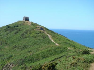
A spectacular, isolated spot on the North Cornwall coast, jutting out into the Atlantic ocean, near Morwenstow north of Bude and the location of Hawkers Hut.
Kit Hill Country Park
Rising to 1,093 feet from the Tamar at Gunnislake, and towering over Callington, Kit Hill is the highest, most westerly point of Hingston Down and offers some of the finest views in Cornwall. Kit Hill Country Park was given to the people of Cornwall in 1985 to mark the birth of Prince William, by his father, Prince Charles the Duke of Cornwall.
Land's End
Mainland Britain's most westerly point, nine miles west of Penzance and one mile from Sennen Cove on The Penwith Peninsula. Awe-inspiring cliff scenery, views to Longships and Wolf Rock lighthouses and 28 miles west, the Isles of Scilly. Heritage centre and tourist attraction. The rugged cliffs and coastline at Land's End are amongst the most dramatic in Cornwall. The very end of the A30 road.
Lizard Point
The most southerly point on The Lizard Peninsula and on mainland Great Britain. The last resting place of many shipwrecks.
Nare Head
Excellent viewpoint just south of Portloe, on The Roseland Peninsula. Between the headland and Veryan is the impressive Bronze Age mound of Carne Beacon, the legendary burial place of Cornish King Geraint and his ship.
Neadland Point
Between Polperro and Lansallos. Excellent views up and down the coast.
Park Head
Just south of Porthcothan With fine views down to Bedruthan Steps.
Pencarrow Head
A headland above the secluded sandy beach at Lantic Bay between Polruan and Polperro.
Pencarrow Point
Close to Crackington Haven.
Pendennis Point
Fine view-point on the southern side of Falmouth.
Penlee Point
Just east of Rame Hesd on The Rame Peninsula. Location of Queen Adelaide's Grotto, built in 1827 to commemorate the visit of King William IV and Queen Adelaide to Mount Edgcumbe.
Pentire Point
Headland on the north side of the Camel Estuary.
Porthmellin Head
Just east of Zone Point,
Rame Head
Prominent headland on The Rame Peninsula Between Looe and Plymouth topped by the ruins of a medieval chapel dedicated to St. Michael.
Rinsey Head
Between Praa Sands and Porthleven.
Rosemullion Head
Between Helford Passage and Maenporth.
Roughtor
At 1311 feet the second highest hill on Bodmin Moor.
Rumps Point
A twin-headland promontory near Polzeath, a favourite view point on the Coast Path owned by the National Trust.
St. Agnes Beacon
One mile south-wast of St. Agnes and overlooks the Atlantic Ocean and is considered "the most prominent feature" of the Heritage coastline, with coastal and inland views that may be enjoyed during hillside walks. During the Napoleonic Wars a guard was stationed on the hill to look out for French ships and light a warning fire on seeing any. It's 629 feet appear all the greater because of it's isolation in the landscape. The view from the top of the Beacon offers a truly panoramic view of the cliffs from St. Ives in the south to Padstow in the North, and to Carn Brea, a few miles south. On the 21st June 2017 fire crews spent all night battling a huge gorse fire on the beacon. Smoke from St. Agnes Beacon could be seen as far away as Newquay and Truro.
St. Agnes Head
Set on the cliff tops at St. Agnes and high above the Atlantic and in the shadow of the Beacon behind you, St. Agnes Head was used as a light anti-aircraft artillery range in the Second World War and during the Napoleonic war it was a rifle range.
St. Anthony Head
At the mouth of The Fal Estuary on The Roseland Peninsula. Site of St. Antony Head Battery.
St. Ives Head
Lovely walk to the headland and up to the little church. Great views in all directions across The Penwith Peninsula including beaches and town. Church itself has an interesting history after being demolished then rebuilt by the army. The building is open limited hours depending on weather.
St. Michael's Mount (NT)
This magical island is the jewel in Cornwall's crown, a national treasure which is a must for every visitor to The Penwith Peninsula. The great granite crag which rises from the waters of Mount's Bay is surmounted by an embattled castle, originally a Benedictine Priory built in the 12th century and daughter house of the famous Mont St. Michel in Normandy. Connected to Marazion by a low tide causeway. An essential stop for those walking The Coastal Footpath.
Sharptor
Overlooking the village of Henwood on Bodmin Moor.
Stepper Point
Headland on the south side of The Camel Estuary.
Stowe's Pound
A huge tor enclosure comprising two massive stone-walls, and giving amazing views all-round, near Minions on Bodmin Moor.
The Cheesewring
A natural formation of balancing rocks near Minions on Bodmin Moor.
Towan Head
One mile west of Newquay.
Trevose Head
Located between Newquay and Padstow, Trevose is the most prominent headland on the north coast rising to 240 feet above the sea, which gives wonderful views on a clear day.
Vellan Head
South of Mullion Cove.
Zennor Head
A 2,460 foot long promontory on the Cornish coast of England, between Pendour Cove and Porthzennor Cove. Facing the Atlantic Ocean, it lies just north-west of the village of Zennor. The promontory was donated to the National Trust in December 1953.
Zone Point
The southernmost extremity of The Roseland Peninsula extending into Falmouth Bay near St. Mawes. It is approximately 550 yards east-southeast of the St. Anthony's Lighthouse on St. Anthony Head.
Ancient Sites in Cornwall Cornwall's Beaches The Coastal Footpath Famous Cornish People