

A forgotten corner of Cornwall
Web: www.visitrame.org.uk
The Rame Peninsula is in South-east Cornwall. It is surrounded by the English Channel to the South, Plymouth Sound to the East, the Hamoaze to the North-east and the estuary of the River Lynher to the North-west. On a clear day, the Atlantic Ocean can be seen from advantageous points from Rame Head. The largest settlement is Torpoint, which is on the Eastern coast, facing Devonport in Plymouth. The peninsula is named after Rame Head, a headland on the South of the peninsula.
Until boundary reform in the 19th century a part of the peninsula was part of Devon, not Cornwall. The Counties (Detached Parts) Act 1844 transferred parts of Maker and St. John, ensuring those parishes (and the peninsula) were entirely in Cornwall. These manors had been possessions of Tavistock Abbey from Norman times.
The Peninsula has been the location of a number of military fortifications defending the Western approaches to Plymouth Sound, including Tregantle and Scraesdon Forts, and Tregantle Down, Hawkins, Rame Church and Penlee Batteries.
Antony
This beautiful old village two miles West of Torpoint on The Rame Peninsula and on the A374, lies at the bottom of the steep hill and was constructed at the end of the 18th century. The church of St. James was enlarged in 1420, but dates from much earlier. There is a pleasant pub, The Ring o'Bells.
Cawsand and Kingsand.
The twin villages of Kingsand and Cawsand on the Rame Peninsula, overlooking Plymouth Sound and the mouth of the Tamar estuary.
Crafthole
Coastal village between Looe and Torpoint on the B3247. The village has a post office, inn and chapels, also there is a golf course nearby. Local pubs are The Finnygook Inn and The Liscawn Inn.
Cremyll
Small village at the start of the B3247 on the Rame Peninsula at the mouth of the River Tamar with passenger ferry to Plymouth started in 1204. The main gates to Mount Edgcumbe Country Park and House are located here. The end of the Coastal Footpath in south Cornwall. Local pub is The Edgcumbe Arms.
Freathy
On coast near Rame Head on The Rame Peninsula. The majority of dwellings are north of the road on the plateau above Freathy Cliffs, while some chalets are sporadically situated on the cliff-side above the beach below. During the summer, the beach is popular with visiting tourists.
Maker
One mile North of Kingsand on The Rame Peninsula. The church of St. Julian is a typical 15th century Cornish building. Fort Picklecombe, near Maker, was commissioned by Lord Palmerston as one of a series of coastal defences against possible French invasion. It has since been converted into residential apartments. William Hughes the barrister and author, was born here in 1803.
Millbrook
A large village in a quiet corner of the Rame Peninsula, South of Torpoint on the B3247. It lies at the head of a long tidal creek and the most attractive approach is along the lane from Mount Edgcumbe especially at high tide. This was once a busy place and there are traces of former industries, including a tide mill, lime-kilns, quarries and brickworks. There are two chapels and a very large church built in 1895 . Local pubs are The Devon and Cornwall Inn and The Heart in Hand.
Polbathic
Known for The Halfway House pub which is situated halfway between Looe and Torpoint on the A374 road.
Portwrinkle
Tiny resort on Whitsand Bay, midway between Looe and Rame Head on The Rame Peninsula, developed around medieval harbour, but much frequented by smugglers. Golf course.
St. Germans
Rural village on the B3249, which was once a harbour, close to the River Lyhner, with outstanding church, former Augustinian priory and cathedral church of Cornwall. 16th century almshouses. Tudor gateway leads to family home of the Eliot's. Still has a main line railway station. Local pub is The Eliot Arms.
St. John
South of Saltash on The Rame Peninsula with Antony House nearby. Local pub is The St. John Inn.
Sheviock
Between Looe and Torpoint on The Rame Peninsula and on the A374. Once an important crossing point of the St. Germans River with a ferry to St. Erth. The church of St. Mary was restored in 1856.
Torpoint
Situated on The Rame Peninsula on the banks of the River Tamar. The listed house and gardens of Mount Edgcumbe and Antony House and Woodland Gardens (NT) are nearby. Car and passenger ferry to Plymouth which pulls itself across on chains. Site of HMS 'Raleigh', a Royal Navy training establishment. The A374 road continues west from the town to the A38 at Trerulefoot.
Torpoint Ferry
A car and pedestrian chain ferry connecting the A374 which crosses the mouth of The River Tamar, between Devonport in Plymouth and Torpoint in Cornwall.
Antony House (NT)
18th Century house near Torpoint on the A374.
Antony Woodland Garden
Adjacent to Antony House.
Grenville Battery
A former coastal artillery battery, built to defend the Royal Naval Dockyard on The Tamar Estuary.
Mount Edgcumbe House and Country Park
Country park incorporating majestic stretch of Heritage coastline on The Rame Peninsula from Plymouth to Whitsand Bay. 16th Century House, gardens, park. Nearby Queen Anne mansion of Antony House (NT).
Penlee Point
Just East of Rame Head. Location of Queen Adelaide's Grotto, built in 1827 to commemorate the visit of King William IV and Queen Adelaide to Mount Edgcumbe.
Polhawn Fort
At the Eastern end of Whitsand Bay was completed in 1864.
Rame Head
Prominent headland on The Rame Peninsula Between Looe and Plymouth.
Wacker Quay
Managed by Tamar Community Trust and volunteers, Wacker Quay provides stunning views and free public access to the River Lynher.
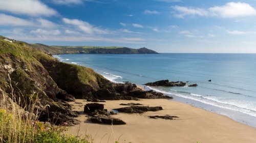
Whitsand Bay
Situated in South-east Cornwall on The Rame Peninsula, runs from Rame Head in the East to Portwrinkle in the West. It is characterised by sheer, high cliffs, dramatic scenery and long stretches of sandy beaches. The South West Coast Path runs the length of the bay.
Cawsand and Kingsand Mount Edgcumbe Country Park
Rame Head The Coastal Footpath