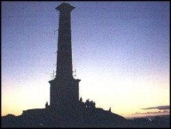


Historic hill topped with a chimney stack
Kit Hill Office, Clitters,
Callington, PL17 8HW
Tel: (0300) 1234 202
Email: environmentservice@cornwall.gov.uk
Web: www.cornwall.gov.uk/parks-leisure-and-culture/parks-and-open-spaces/country-parks/kit-hill-country-park
Web: www.visitcornwall.com/things-to-do/walking/kit-hill-country-park
Stoke Climsland Parish Council

Kit Hill Country Park (which includes the hill and surrounding areas), was given to the people of Cornwall in 1985 to mark the birth of Prince William, by his father, Prince Charles the Duke of Cornwall. It is managed by Cornwall County Council. With 400 acres available for public enjoyment, Kit Hill is an ideal place for a wide range of activities including kite flying, bird watching, orienteering and picnicking. With several miles of path there are excellent opportunities for walking and exploring. Lies just north of the A390 road.
Rising to 1,093 feet from the Tamar at Gunnislake, Kit Hill is the highest, most westerly point of Hingston Down and offers some of the finest views in Cornwall.
Due to the wild, rugged nature, many of the paths are unsuitable for some visitors, particularly those in wheelchairs. Vehicular access however is good and action is in hand to improve access opportunities.
There are no toilet facilities on Kit Hill.
The decline in industrial activity combined with the lack of agricultural improvement means that Kit Hill has become an oasis for wildlife.
Apart from small scale cultivation in the Bronze Age and Medieval times Kit Hill has only been lightly grazed. This combined with period cutting and burning of vegetation has enabled heathland to survive, characterised by a mix of heathers, gorses, grasses and Whortleberry.
The Hill supports a variety of insects, reptiles, birds and mammals. Adders can often be seen basking in the sun and in addition to heathland specialists such as Stonechat, Treepipit and Skylarks, birds of prey such as Buzzards and Kestrels soar overhead in search of a meal.
On other parts of the Hill deciduous woodland is returning and quarrying works have become valued wetland coming alive with frogs and toads in spring and dragonflies in late summer.
Nature has even reclaimed mine workings with bats roosting deep underground. Much of Kit Hills flora and fauna is nationally rare and protected by law.
For Thousands of years Kit Hill has been a focal point for human activity.
Prehistoric people left behind their mark with a Neolithic long barrow (approx, 3,000BC) and Bronze Age round barrows (2,000-1,500BC) standing as testament to the importance of the Hill.
In 1780 a castle folly built on the summit by Sir John Call of Whiteford, near Stoke Climsland, so he could admire the views and appreciate the famous 838 battle of Hingston Down. He intended it to be the setting for his tomb but he was eventually buried in London.
The summit is still used for ceremony with the annual Callington Old Cornwall Society Midsummer Bonfire.
It is Kit Hill's industrial past that has left the greatest mark. The 80 foot ornate summit chimney stack built in 1858 to serve the mining complex of Kit Hill Great Consols/Kit Hill United is one of the areas most famous landmarks. The chimney served a steam engine that pumped water and lifted ore from the deep mine workings. The tunnel like flue, which carried arsenic fumes, crossed on the approach to the main mine shafts. Below these remains lies a Bronze Age burial mound. The surface mining and quarrying remains are among the finest in England.
The hill was formed by the same molten granite pushing up from the earth's core as its larger moorland neighbours - Bodmin Moor and Dartmoor. Gasses and solutions rich in minerals found their way into cracks in this granite and the surrounding sedimentary rocks. These solidified and crystallised forming veins rich in ores such as tin, copper, arsenic and wolfram.
The search for minerals dates from at least medieval times when 'shode' (stones containing tin ore) was either dug dry from small pits or separated through sorting mechanisms of a flow of water in stream works. From the 15th and 16th centuries the tin 'lodes' themselves were dug into from the surface by long narrow open works and closely spaced pits. By the 18th century men were going underground in the shaft and adit mines scattered all over the hill.
Large scale quarrying, for quality granite, began in 1880. The granite was used for sea defences in Plymouth, London and as far away as Singapore. The stone was shaped and finished within the quarry and lowered on trucks down the incline to sidings which connected to the 3 foot 6 inch gauge East Cornwall Mineral Railway.
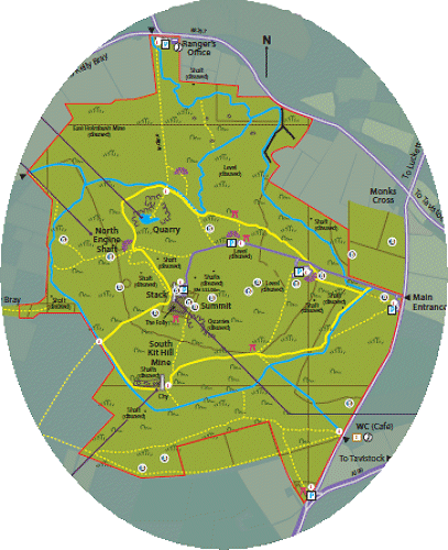
North Engine Shaft, also known as Old Crumbly, is over 200 yards deep. The smaller shafts, now protected by fencing, were used for ventilation and prospecting.
South Kit Hill Mine opened in 1856, reached a maximum depth of over 100 yards. Around the chimney lie the remains of an engine house with its flywheel slots and six circular 'buddles' where crushed rock was stirred to separate heavy tin ore from waste 'tailings'.
Mining continued up until the First World War when Wolfram (used in making steel) was extracted by cutting 'levels' into the eastern side of the hill. Quarrying ceased in 1955.
In 1877 a company called Kit Hill Tunnel Ltd began work on both the south and north sides of the hill to create a tunnel which would be two miles long. The southern portal was at Silver Hill, and that at the north was near a small mine called Excelsior. However, due to the toughness of the underlying bedrock, progress was costly and slow, and ceased about a year later. In 1881 a new company named Kit Hill Great Consols took over the setts of Kit Hill United and Excelsior mine. They deepened the North Engine Shaft to 112 fathoms and lengthened the tunnel running south to meet it. However, this too was proving too costly, and wound up in 1885, before it was half-way complete. Several later attempts were made to extend the Excelsior Tunnel, but by 1938, it was still only 2,400 feet long. However, in 1959 the Atomic Energy Authority took over operations, and used the tunnel for underground explosions.
Construction of The Tamar, Kit Hill and Callington Railway started in 1864. The name was later changed to the East Cornwall Mineral Railway, and the line opened in 1872. Seven miles long, it ran from Calstock's river frontage, past Kelly Quay and Drakewalls and the Gunnislake quarries, along the northern flank of Hingston Down to below Kit Hill at Kelly Bray, where an inclined tramway connected with it. It amalgamated with the Plymouth, Devonport and South Western Junction Railway crossing the Tamar above Calstock and onto the junction at Bere Alston. The Gunnislake to Bere Alston section still survives as part of the Tamar Valley Line.
Just north of the A390 road between Callington and Gunnislake.
Opening TimesAll Year Admission Free |
Bodmin Moor Callington Calstock Gunnislake Walks and Walking in Cornwall
Cornwall's Country Parks Cornwall's Lakes and Reservoirs